⇨ See the Dot Performances Display
⇨ See the Dot Positioning Display
⇨ See the Dot Environment Display
⇨ See the Compound Track Display
⇨ See the Dot Performances Display
⇨ See the Dot Positioning Display
⇨ See the Dot Environment Display
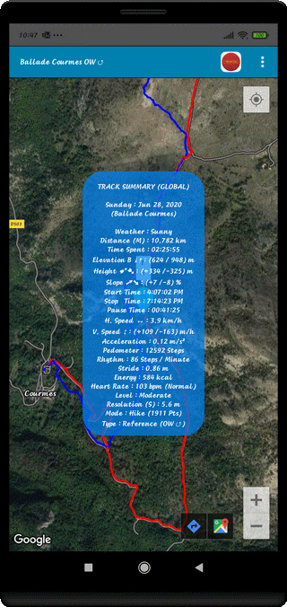
⇨ Title of the Trip at the Top of Screen
⇨ Title of the Display
⇨ Week Day and Date
⇨ Title of the Walk
⇨ Weather or State of the Sky
⇨ Travelled Distance (M or P : Mountain or Plain) in km
⇨ Remoteness from Starting Point
⇨ Time Spent during the Walk H:M:S
⇨ GPS or BAROMETRIC Elevation ↡↟ (Minimum / Maximum) (m)
⇨ Cumulative Height ➹➷ (Ascent / Descent) (m)
⇨ Average Topographic Slope (plus & minus %)
⇨ Departure Time H:M:S
⇨ Arrival Time H:M:S
⇨ Pause Time H:M:S
⇨ Average Horizontal Speed (km/h)
⇨ Average Vertical Speed (km/h)
⇨ Average Acceleration (m/s2)
⇨ Estimated Number of Steps
⇨ Average Rate (Steps/Minute)
⇨ Average Stride (Meter)
⇨ Energetic Cost (kcal)
⇨ Average Heart Rate (bpm) (*)
⇨ Level of Difficulty (4 Levels)
⇨ Spatial or Temporal Resolution (meters or seconds)
⇨ Track Mode / Number of Recorded Positions
⇨ Kind of Record (Reference, Access, Guided, Secondary)
Compound, Simple or Multiple Track (CT, ST or MT) + Symbol
(*) : Needs an External Adapted Sensor (BlueTooth Smart Technology)
⇨ Easy, Moderate, Strenuous or Challenging
⇨ For a Compound Track (CT), there is a Global and a Detailed Synthesis
⇨ For a Simple Track (ST), there is only a Global Synthesis
⇨ Move the Map and Strongly Zoom
⇨ Interact on the Path Points
⇨ Synchronize the Audio on different Positions
⇨ Accede different Classifications when Touching the Display
⇨ Display the Map in PLAN Mode
⇨ Display the Reference and Access Track
⇨ Display the Guided Track
⇨ Display the Reference and Guided Tracks
⇨ To Light Off the Display when Touching the Mapping
⇨ To accede to the different Guiding Possibilitie to each Position
⇨ Light OFF the Analysis Window with the BACK Control (↶)
Top of Page