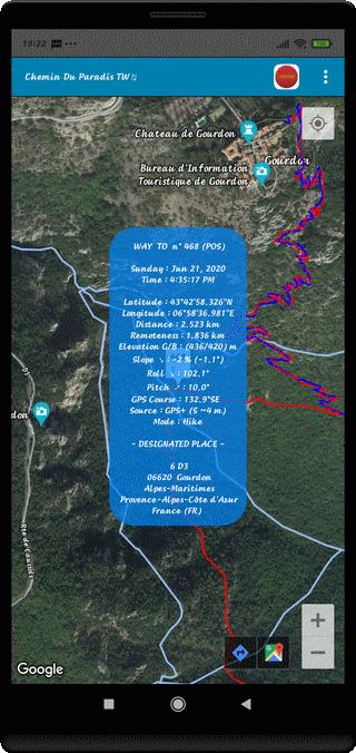
⇨ See the Dot Performances Display

⇨ See the Dot Environment Display
⇨ See the Dot Performances Display

⇨ Title of the Trip at the Top of Screen
⇨ Kind of Record - Dot Number - Display Type (POS)
⇨ Week Day and Date
⇨ Schedule Time (H:M:S AM/PM) at this Place
⇨ Latitude of the Place (Degree:Minute:Second:Thousandth & Cardinal)
⇨ Longitude of the Place (Degree:Minute:Second:Thousandth & Cardinal)
⇨ Travelled Distance to Reach this Place (km)
⇨ Remoteness from Starting Point (km)
⇨ GPS/BARometric Elevation of this Place (m)
⇨ Topographic Slope (%) and Angle of Slope (°) at this Place
⇨ Roll Angle at this Point (°)
⇨ Pitch at this Point (°)
⇨ GPS Course or Azimuth at this Point (°)
⇨ Localization Mode and Location Accuracy (Spatial(m) or Temporal(s))
⇨ Locomotion Mode
⇨ Designated Place
⇨ Elements for Localization (Address, City, Area Name, Country Name & Country Code)
⇨ Light OFF the Analysis Window with the BACK Control (↶ )
⇨ Select some other Points, directly
⇨ Or Sequential, with the Sound Control (+) or (-)
⇨ Observe the Map in different Way by Screen Rotation
Portrait -> Landscape -> Portrait
Top of Page