⇨ See the Dot Environment Display
⇨ See the Dot Positioning Display
⇨ See the Dot Environment Display
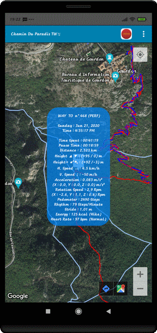
⇨ Title of the Trip at the Top of Screen
⇨ Kind of Record - Dot Number - Display Type (POS)
⇨ Week Day and Date
⇨ Schedule Time (H:M:S AM/PM) at this Place
⇨ Timer to Reach this Place (H:M:S)
⇨ Pause Time (H:M:S) for this Walk
⇨ Travelled Distance to Reach this Place
⇨ Global Height ▲ (Place Elevation - Start Elevation) to Reach this Point (m)
⇨ Cumulative Height ➹➷ to Reach this Point (m)
⇨ Instantaneous Horizontal Speed in this Point (km/h)
⇨ Instantaneous Vertical Speed in this Point (m/h)
⇨ Instantaneous Acceleration in this Point (m/s2)
⇨ Acceleration Projections on the X, Y et Z Axis (m/s2)
⇨ Rotation/Resonance at this Place (RPM)
⇨ Rotation/Resonance on the X, Y et Z Axis (RPM)
⇨ Step Number (estimated) to Reach this Place
⇨ Step Rate (estimated) in Steps/Minute at this Place
⇨ Size of the Stride (estimated) in meter
⇨ Energetic Cost (kcal) at this Place and Locomotion Mode
⇨ Heart Frequency (Beats/Minute) at this Place precisely
⇨ Light OFF the Analysis Window with the BACK Control (↶ )
⇨ Select some other Points, directly
⇨ Or Sequential, with the Sound Control (+) or (-)
⇨ Observe the Map in different Way by Screen Rotation
Portrait -> Landscape -> Portrait
Top of Page