⇨ START RECORD (Seconds) / STOP RECORD (Seconds)
Start and Stop the Recorder
⇨ VIEW THE TRACK (Locations)
Displays the Travelled Path, Map, Location Characteristics and Step by Step History
View Track Path
Starting Point Aerial View
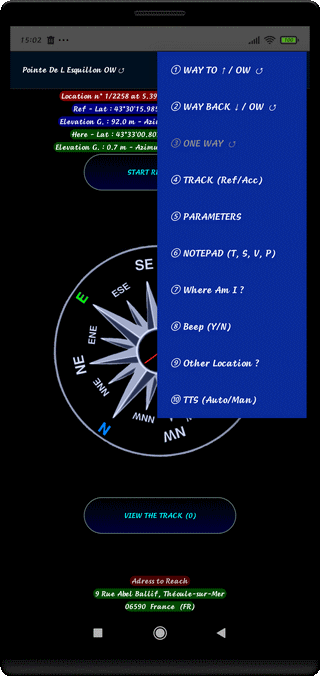
⇨ ① WAY TO ↑ / OW ↺
For a Compound Track (CT), choose the Way TO (TO ↑) or ONE WAY Path (OW ↺)
(Allow the Recording of Positions History of WAY TO or OW Path)
⇨ ② WAY BACK ↓ / OW ↺
For a Compound Track (CT), choose the Way BACK (BACK ↓) or ONE WAY Path (OW ↺)
(Allow the Recording of Positions History of WAY BACK or OW Path)
⇨ ③ ONE WAY ↺
Not Used
⇨ ④ TRACK (Ref/Acc)
Not Used
⇨ ⑤ PARAMETERS
Eventually, change some parameters (Locomotion, Mode, Weather, Start Elevation...)
See Tuning the Parameters
⇨ ⑥ NOTEPAD (T, S, V, P)
Add Medias (Texts, Sounds, Videos, Photos) during the Trip and Monitoring
See Using the Notepad
⇨ ⑦ Where am I ?
Request to Obtain the Address of the Place (in the City)
⇨ ⑧ Beep (On/Off)
Allow Searching Beep or Not
⇨ ⑨ Other Location ?
Select another Position with a Number
⇨ ⑩ TTS (Auto/Man)
Automatic or Manuals Voice Announcements
⇨ 1st Long Touch = With Automatic Voice Announcement
⇨ 2nd Long Touch = Without Automatic Voice Announcement
⇨ Screen Touch = Announce the Direction to Follow and the Remaining Distance
⇨ Touch Application Icon on Action Bar Menu
Detailed Display of Explanations from the Support Site
⇨ Choose WAY TO, WAY BACK to allow the Record of the Trajectory
⇨ The Parameters are Preferences Parameters
⇨ The displayed Elevation is coming from the GPS
⇨ The Period of Beeper is 1 Second when arriving near the Reference Position
⇨ Exit from Function with Return Touch (↶ )
While searching, the User can :
⇨ See the Position on the Map and the Travelled Track (AERIAL VIEW)
⇨ The Goal is to be correspond the Geographical Positions and,
in a lesser measure, the Elevations of the Reference and the User Positions.
⇨ Light OFF the Screen and Light ON at each Moment (Beeper and Announcements audible)
⇨ activate the Notepad, take Photos and take Videos or Notes
⇨ Ask for the Address of a Place (City)
⇨ Necessary to be connected to the GSM Network
for the Map
and the Request for a Place Address
⇨ Necessity to be connected to the Satellite for the Guidance
⇨ SIMPLE TRACK (ST) : Press WAY TO allow the Recording of the Positions
Visible on the Map if you Press AERIAL VIEW
⇨ COMPOUND TRACK (CT) : if followed by a BACK Track, Press One Time WAY TO end the WAY TO Track
and one time on WAY BACK Open the WAY BACK Track
⇨ At Horizontal in your Hand, Screen to the Sky (HPF)
Top of Page