⇨ How to Interact with this Function
⇨ Search Starting Point of a Track
with the knowledge of its Position, its Elevation and the Reference Track
Once the Goal is reached, the User launches the Automatic Guiding Mode on the same Track
⇨ Knowledge of a Place (Classification)
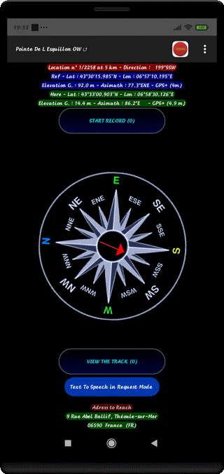
⇨ Title of the Walk - Symbol - Kind of Track (OW or TO or BACK)
⇨ Searched Location Number / Number of Points, Flat Distance to the Position (m)
⇨ Geographical Coordinates (Reference) Latitude & Longitude
⇨ GPS Elevation (m) - Azimuth (°) + Orientation - Provider Name - Localization Accuracy (m)
⇨ Geographical Coordinates (User) Latitude & Longitude
⇨ GPS Elevation (m) - Azimuth (°) + Orientation - Provider Name - Localization Accuracy (m)
⇨ Title Line
⇨ Address of Position Searched (if it exists)
⇨ Name of the Locality of the Searched Place
⇨ The Compass shows the Magnetic North Direction
⇨ The Green Arrow shows the Direction to be followed
⇨ Green Color if the User follows the Right Direction, Red Color if not !
⇨ Change of Color (Dark Green) Line "POSITION" less than 100 m of the Goal
⇨ Information "Try Automatic Guiding !" less than 100 m of the Goal
⇨ Voice Announcement of the Direction to be Followed (8 Directions) and Remaining Distance
⇨ Voice Announcement of the Current Address on Demand
⇨ Searching Beep with variable Period (1 Second near the Searched Place)
The Voice Announcements are also pronounced when Screen is Off
Top of Page