⇨ How to Interact with this Function
⇨ Record a Trip to Know
the Characteristics (Classification)
⇨ Record Visual Memories (Videos and Photos) or Sounds of this Journey
⇨ Follow your Track on a Map
⇨ Control and Survey your Heart Rate (HR)
⇨ Have the Possibility to Share this Track
⇨ Perform Magnetic Searches
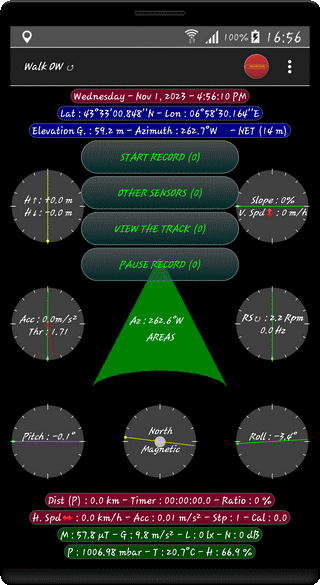
⇨ Track Title - Kind of Track (OW↺ or TO↑ or BK↓)
(OW : One Way Path, TO : Forward Path, BK : Backward Path)
⇨ Day - Date - Time - AM/PM
⇨ Geographic Coordinates : Latitude & Longitude
⇨ GPS/BAROMETER Altitude (m) - Azimuth (°) + Cardinal Point
- Kind of Location and Accuracy (m)
⇨ Distance (Model) (km) - Timer (H:M:S:Tenth) - Progress Ratio (%)
(Relative to the Estimated Track Duration of Parameters Section)
⇨ Speed (km/h) - Acceleration (m/s2) - Pedometer (Steps) -
Energy Cost (kilo-calories)
⇨ Magnetic Field (µTesla) - Gravity (m/s2) - Luminosity (Lx) - Noise Level (dB)
⇨ Atmospheric Pressure (mbar) - Ambient Temperature (°C) - Relative Humidity (%)
⇨ Global Height (+/-/~/m)
or Difference of Height (+ and -) if the Cell Phone has a Barometer
⇨ Instant Acceleration (m/s2) and Pedometer Threshold (Red Vector in m/s2)
⇨ Pitch Angle (°) (Default O/M/G/A/R Command)
or Magnetic Component Mx (µTesla)
or Gravitational Component Gx (m/s2)
or Acceleration Component AccX (m/s2)
or Vibration Component RSx (Rpm and Hz)
⇨ Estimated Topographic Slope (%)
Timer (s) or Vertical Speed (m/h) if Terminal has a Barometer
⇨ Resonance and/or Vibrations (Hz & RPM)
⇨ Roll Angle (°) (Default O/M/G/A/R Command)
or Magnetic Component Mz (µTesla)
or Gravitational Component Gz (m/s2)
or Acceleration Component AccZ (m/s2)
or Vibration Component RSz (Rpm and Hz)
⇨ Average Azimuth (°), Cardinal or Inter Cardinal Point
⇨ Area Name for the Current Record
⇨ GPS Course (°) in GPS+ Mode
(Direction Followed by User on Return Way
or Destination Direction if Initialized)
Initialize the Destination Position before Running the Record
In case of a Simple Track (OW), Rotate the Display in Landscape Mode
to Find the Return Back Direction
⇨ Magnetic North Direction (Default O/M/G/A/R Command)
or Magnetic Component My (µTesla)
or Gravitational Component Gy (m/s2)
or Acceleration Component AccY (m/s2)
or Vibration Component RSy (Rpm and Hz)
⇨ Speed Alarm if SPD ⩾ Speed Threshold (See Tuning Parameters)
⇨ Magnetic Alarm if Amplitude ⩾ Alarm Threshold (See Tuning Parameters)
⇨ Heart Alarm if HR ⩾ Heart Threshold (See Tuning Parameters)
⇨ According to the Terminal AND in Recording Mode
Flashing Diode Red with 7 Seconds Period
⇨ During GPS Loss Detection, Flashing of the
GPS Lost Notification Message with Number and UnDetect Duration
⇨ While Walking, a Bouncing Ball crosses the Screen from Left to Right
⇨ Ball Speed is proportional to the Movement Speed
⇨ Vibration Amplitude is proportional to the Acceleration
⇨ Its Color is Relative to the Speed
White : 0 ≤ Speed < 5 km/h
Gray : 5 ≤ Speed < 12 km/h
Yellow : 12 ≤ Speed < 50 km/h
Green : 50 ≤ Speed < 90 km/h
Blue : 90 ≤ Speed < 110 km/h
Magenta : 110 ≤ Speed < 130 km/h
Red : Speed ≥ 130 km/h
Top of Page