This Application is based on Investigation Software
who will try to tell you everything about :
⇨ your Hiking (in the Mountains)
⇨ your Journey (by Car)
⇨ your Route (in the City)
⇨ or your Exploits in Extreme Sport (Skiing, other)
⇨ Orange Marker : Single Track Departure
⇨ Red Marker : Compound Track Departure (TO)
⇨ Blue Marker : Compound Track Departure (BACK)
⇨ These Characteristics are based on Averages
or Direct Measurements
⇨ These Characteristics are based on Measurements
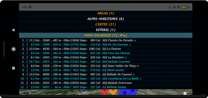
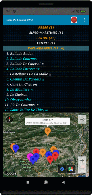
⇨ The Sorting Criteria (6) are : Difference of Height, Distance, Duration, Speed, Chronological or Alphabetical
⇨ Ascending or Descending Order
The Application allows :
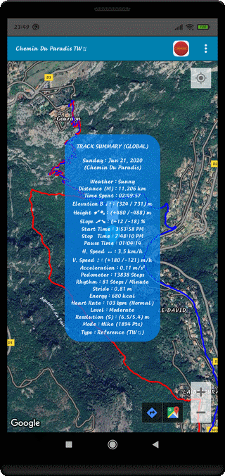
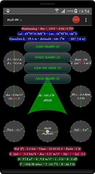
⇨ Real Track Recordings
⇨ Monitoring Progress in the Field
⇨ Guidance by Observation
⇨ Elevation Control and Slope
⇨ Control of one's Position in Space
⇨ and Time, Distance Traveled, Azimuth
⇨ or the Route Followed
⇨ Horizontal and Vertical Velocities
⇨ 3-Axis Acceleration
⇨ Environmental Parameters
⇨ Control of all Sensors
⇨ and Possibly Heart Rate
The Application allows :
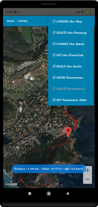
⇨ Virtual Track Creation
to Estimate the Length and Duration of a Journey
and Possibly the Altitude of the Positions
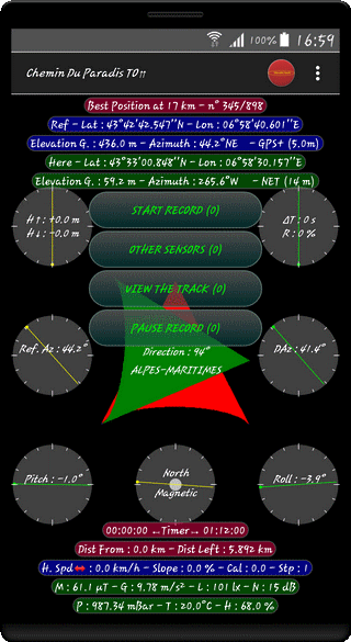
⇨ Guidance, in the Field, with the FOLLOW Function
in Step by Step Mode and Cloning are Possible
Advances or Delays are calculated for each Position
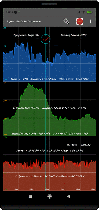
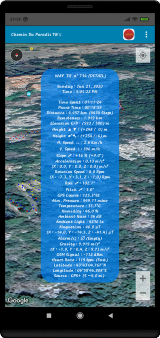
⇨ 23 Quantities can be analysed
⇨ including 4 Quantities on 3 Axes
⇨ Any Relocatable Feature on the Map
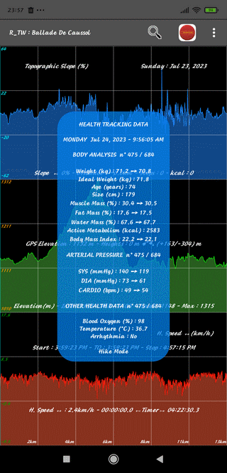
⇨ The App Records Heart Rate
Using an External Sensor and Traces History
⇨ It can exchange and compare the values of various
Parameters from a Body Analysis System
⇨ The Application allows Search and Registration
of 360° Panoramas from each of the Positions
⇨A Distinction is made between the Areas Panoramas
and the Track Panoramas
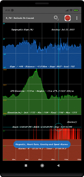
⇨ The Application allows the Search for Magnetic Manifestations
In the example above, it is probably Presence of Water in the Basement
Simply place the Magnifying Glass on the Vertical Vector
(M) to access the Position on the Ground
⇨ Application Enables Detection of Specific Areas
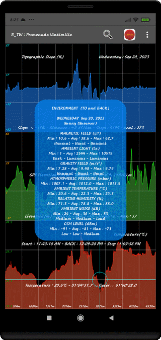
The Research concerns :
⇨ Low Noise Zones
⇨ High Brightness Zones
⇨ Temperate Zones (*)
Example above : Cold Zone
in the Vintimiglia Old Town (Italy)
⇨ Low Humidity Zones (*)
(*) : SmartPhone with Temperature and Hygrometer Sensors
⇨ GSM Signal Reception is also Tracked
and Helps Identify Low Level Reception Zones
⇨ Application Enables Searching Areas
with Low Level GSM Reception
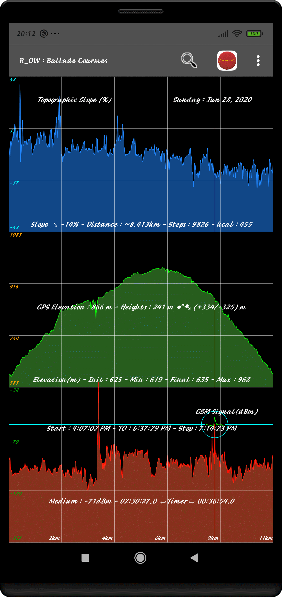
⇨ GSM Signal Reception Level is Tracked
wich makes it Possible to Identify Critical Zones
for the GSM Reception in the City as well in the Mountain
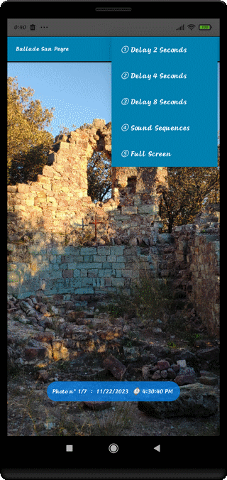
⇨ Photography is possible during the Exhibition
Monitoring is carried out by Relecture
or by Slide Show Generation
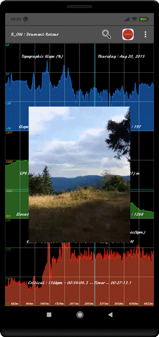
⇨ Video Footage Search
indexed by the Cursor Position is Achievable
in the Graphic Analysis
There are many Possibilities :
⇨ Simple Definition Vidéo (SD)
⇨ Time Lapse Video
⇨ Configurable Fixed Recurrence Photography
⇨ Low or High Quality Audio
⇨ Route Optimization is easy
by Comparing the Characteristics To and From
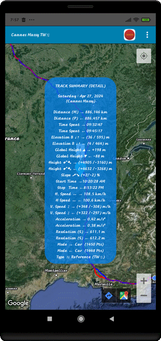
Distance Motorway Route 1773 km
⇨ A maximum Speed of 131.2 km/h will be read
⇨ a Journey Time of 19H18
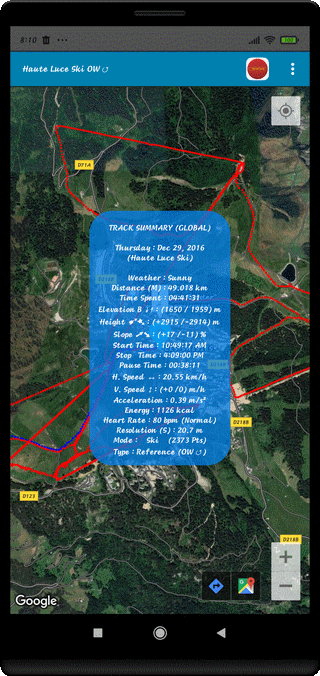
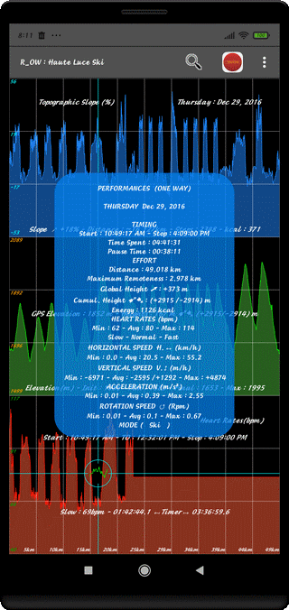
Recording of a Ski Day in "Les Saisies"
⇨ Distance traveled : 49 km for 4 hours 40 minutes
⇨ Cumulative Elevation gain : 2915 m
⇨ Hearth Frequency : 62 to 114 bpm
Recording of a Steep Hike
Effect on Heart Rate
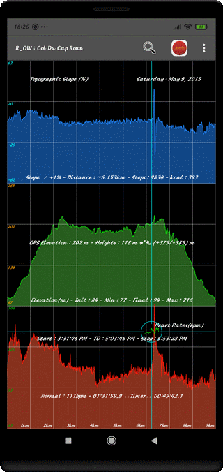
Area Identification : Saint Barthelemy Mountain
83700 - Esterel/Var/Provence-Alpes-Côte d'Azur
Type : Hands-Free Ascension (Cursor Position)
Heart Rate Ranging from 92 to 149 bpm
There Are Several Ways to Maintain the Smartphone
Depending on the Locomotion Mode or Usage
⇨ During the Walk, the Hike
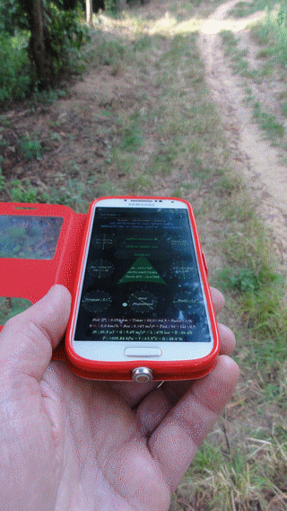
This Way of Holding Allows You to Examine the Screen
at any Time and to Request the Mapping
to Find Your Way Around
HPF Position = Horizontal Portrait Forwards
⇨ During a Travel Without a Consultation
in a Case attached to the Belt
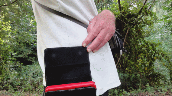
This Way Totally Frees the Hands
The Light Sensor is however Obscured
VLR Position = Vertical Landscape Right
⇨ For Buried Magnetic Object Detection
or presence of Water in the Basement
The SmartPhone can be Attached to a Pole at Ground Level
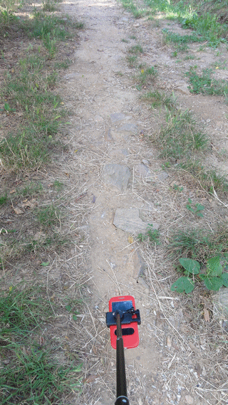
In this case, the Audible Alarm must be Allowed
Interest: the Magnetometer is as Close as Possible to the Ground
⇨ For a Bicycle or Mountain Bike Trip
The SmartPhone is Attached to the Handlebar with a Bracket
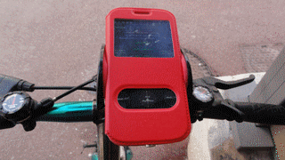
In this case, the System will Record the Entire Course
with Locations, Speeds and Accelerations
HPF Position (Automatic with Inclination)
⇨ For a journey All aboard
The SmartPhone is Attached Under the Windshield
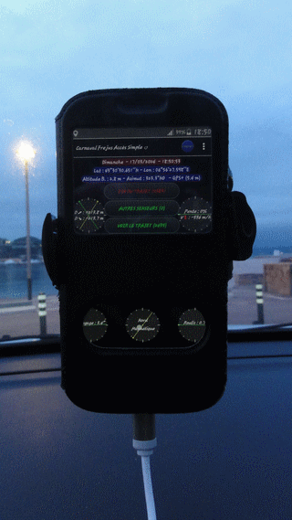
In this case, the System will Record the entire Trip
even for Hundreds of kms
VPB Position (Vertical Portrait Backwards) Automatic
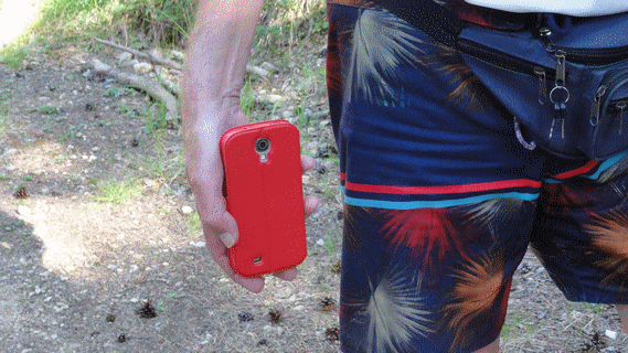
⇨ For a Record in Permanent Video Mode
the CellPhone must be kept in the Hand
in Vertical Position (Portrait or Landscape)
Camera filming Everything Forward
In this case, the System will Record the entire Course
without further Manipulation, until the End
Filming continuously in the Axis of Displacement.
Similarly, for the Programmed Fixed Recurrence Photographic Mode
(which will produce a Large Number of Files)
or Time Lapse Mode
In this Record, a connected Sensor has been used (Cardio Sensor Polar H7 or H10)
Photographs are taken during the Trip Recording
and can be accompanied by the Sounds of the Place
(Raw, unprocessed, unsynchronized sounds)
(Footsteps, Breathing, Birdsong, Nature Sounds..)
During the Walk, Magnetic Alarms Sound often
The Reason is probably the Presence of Water in the Basement (Wooded Area)
TrajecSan, Journey Scanner, shows a real ability to adapt
to a large Number of Situations
It provides Meaningful Informations
It leads to Knowledge of Places and Yourself
It is a Versatile, Powerful and Efficient System
Be Careful, the System is not easily Mastered !
It is Fiery but not Indomitable