TRAJECSAN is a Recorder and Tracks Classification System
It's a Mobile Application for Cell Phones
It is both :
⇨ a Trajectories Controller
⇨ a Walk Assistant, acting as a Guide
⇨ a Track Scanner
⇨ an Environment Detector
It works under ANDROID from the Version 5.0 (Lollipop)
Its Essential Objective is to bring knowledge on your Paths
It's, first of all, a Multi-Sensors and Multi-Modes System

Its Features allow to :
⇨ Elaborate Routes for Tourist, Professional or Personal Purpose (Souvenirs)
⇨ Record Photos, Videos or Sounds Files associated with this Journey or Travels
⇨ Help to find the Starting Point of these Trips (in order to share with Friends)
⇨ Guide anyone who wishes to make these trips (in order to share with Friends
⇨ Create Virtuals Tracks to Estimate Characteristics in Distance and Length
⇨ Analyze the relative Particularities of these displacements
⇨ Export or Import Files between multiples Cell Phones or Tablets
On Launch, the list of the Journeys recorded by the User is displayed
A Classification allows the Comparison of Tracks Each Other
Select a Title allows a Set of 9 Activities :
⇨ CREATE Tracks in the Nature or in City
⇨ COMPOSE Virtual Tracks
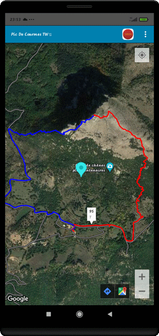
⇨ DISPLAY the Tracks on a Map and also the Access Tracks
⇨ ANALYZE, a posteriori, all the Data recorded by the System
and Look at the precise Place, where some events occurred
(Aerial View, Video or Photo Continuous Modes)
⇨ WATCH Videos, the associated Movies
⇨ LOOK at Photos associated to their Sounds or Comments and Create Diaporamas
⇨ GUIDE be a Guide throughout the Course or CLONE
your Own Walk
⇨ FIND the Starting Point and Intermediate Points
⇨ Geographical Position : Latitude
⇨ Geographical Position : Longitude
⇨ The Elapsed Time
⇨ The Travelled Distance
⇨ The Horizontal Speed
⇨ The Vertical Speed
⇨ The Acceleration (Resultant and 3 Axis Components)
⇨ The Resonance and the Vibrations (Resultant and 3 Axis Components)
⇨ The GPS Elevation
⇨ The BAROMETER Elevation (for the Terminals with Barometer)
⇨ The Topographic Slope
⇨ The Global and Cumulatives Heights (+/-)
⇨ The Magnetic Field : Resultant (Module), the X, Y, Z Components
⇨ The Gravitational Field (Resultant and 3 Axis Components)
⇨ The Atmospheric Pressure (Terminal with Barometer)
⇨ The Ambient Temperature (depends on Cell Phone)
⇨ The Relative Humidity (depends on Cell Phone)
⇨ The Lighting
⇨ The Ambient Noise
⇨ The GPS Accuracy (and the Number and Location of GPS Losses)
⇨ The Remoteness from the Starting Point
⇨ The Azimuth Angle (Magnetic North) or the GPS Course
⇨ The Roll Angle (Lateral Inclination)
⇨ The Pitch Angle (Longitudinal Inclination)
⇨ The Localization of Magnetic, Gravitational, Speed and Heart Alarms
⇨ The Intensity of GSM Signal
⇨ The Instantaneous Heart Rate (Terminal associated with a Heart Rate Sensor)
⇨ The Blood Oxygen Ratio (SpO2) after Manual Inputs from an Oxymeter
⇨ Simple Track (OW) : a single Record
⇨ Compound Track (CT) : 2 Records, one to Go (TO) and one other for Return BACK (BK)
⇨ MultiSegments Tracks (MT) : several Elements making up a long Track
⇨ Reference Track (Ref) : your Hike for Example
⇨ Access Track (Acc) : the One that brings you to the Starting Point
⇨ Guided Track (Gui) : the One you generate by Cloning a Journey
⇨ Sounds, Nature Noise, Discussions, Speaking Comments
⇨ Videos Product Short or Long Play
⇨ Permanent Videos (Simple Definition) or Time Lapse
⇨ Recurrent Photos with Period > 1 Minute
⇨ Digital Photos
⇨ 360° Panoramic Views
⇨ Texts
⇨ French
⇨ English
⇨ German
⇨ Italian
⇨ Spanish
(Choice According to Settings)
⇨ Track Name : to be Initialized at First (When Recording a New Track)
⇨ Locomotion Mode : if different from the Preferences (See Parameters)
⇨ State of the Sky : if different from the Preferences (See Parameters)
⇨ Initial Value of the Barometric Altimeter (eventually) : if different from the Preferences (See Parameters)
All the Quantities Recorded by TRAJECSAN are relocated, that means you can
find the Aerial View of a Place where an Event occurred (Magnetism, Speed, Acceleration)
If the User record a Track in Permanent Video Mode, he can
see the Movie at this Place precisely

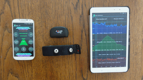
⇨ GALAXY S4 under Android 5.0.1 - RAM : 2 Go - Resolution 1920x1080 Pixels
Very Good Terminal with a low Weight (130g) and all Sensors
There is a link gives a list of Systems with Temperature/Humidity Sensors (to be verified) :
Cell Phones with Temperature/Humidity Sensors
⇨ GALAXY TAB PRO 8.4 Resolution 2560x1600 Pixels under Android 4.4.2
It's difficult to find a better Screen in term of Resolution
The Author uses the S4 as a Recorder and the Galaxy Tab as an Analysis System
⇨ CARDIO SENSOR H7 or H10
Permanents Measurements, very accurate, and Low Consumption
On the mentioned Terminal, the autonomy can reach 6 Hours in a Normal Record
but only about 3 Hours about in Permanent Video Mode.
In those 2 cases, the Recording was made with Screen off
without Sending or Receiving Telephone Calls
⇨ In the Nature, to Visualize the Map, to be connected to the GSM Network
⇨ If not, in the Recording Mode, only the GPS is necessary
⇨ At Home, for the Consultations, the WIFI is preferable
⇨ Be Careful to Use a Cell Phone with a non Magnetic Case !
Many of these will falsify the Azimuth Measurement
and will make your Orientation difficult (In that Case, use the GPS Course insteed of Azimuth)
⇨ It is strongly advised to use a Stylus for Screen Interactions

Evaluation Version : Android API 21 -> API 36 - Executable File Size : 1.01 Mo

Evaluation Version : Android API 21 -> API 36 - Executable File Size : 1.01 Mo
![]()
Evaluation Version (Current) : Android API 21 -> API 36 - Executable File Size : 1.525 Mb
![]()
Then, Go to Download Folder and Install the Application...
Good Luck !
Send an Email for some Suggestions